01
Transport Infrastructure Mapping
Capture detailed spatial data for roads, highways, rail networks, bridges, tunnels and other transportation assets.

High-Speed, High-Accuracy Reality Capture for Complex Environments
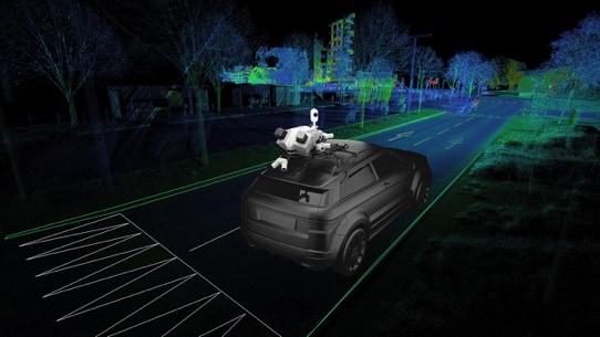
Our Mobile Mapping Services, powered by the Leica Pegasus TRK 500 EVO, provide rapid, high-density and survey-grade spatial data capture across large, complex and linear environments.
By combining LiDAR scanning, high-resolution imaging, Integrated Global Navigation Satellite System (GNSS), Inertial Measurement Unit (IMU) and Simultaneous Localization and Mapping (SLAM) technologies, we accurately capture detailed 3D information while minimizing disruption to ongoing operations.
The resulting high-density 3D point clouds, imagery and geospatial datasets provide a reliable digital representation of existing conditions, enabling better design decisions, faster verification, improved asset visibility and more efficient project delivery.
Capture detailed spatial data for roads, highways, rail networks, bridges, tunnels and other transportation assets.

Rapidly survey streetscapes, public spaces and municipal infrastructure to support planning, management and asset inventories.

Provide accurate existing-condition data for engineering design, dimensional verification, clash identification and project validation.

Create comprehensive digital inventories and capture asset condition data to support maintenance planning, inspections and lifecycle management.

Monitor construction progress, verify installed works against design requirements and produce accurate as-built records.
Captures millions of spatial data points per second while in motion, dramatically reducing field time compared with traditional survey methods.
Integrated GNSS, IMU and SLAM technologies maintain accurate positioning and data capture across challenging environments, including urban corridors, tunnels and underpasses.
Combined with high-resolution imagery, the resulting survey-grade data enables detailed asset inspections, condition assessments and monitoring, digital twin development, and long-term infrastructure management and planning.
Core services
Explore related pathways under Digital Services — designed for clarity, built for delivery.
Start the conversation